
Submitted by guest blogger Phil Brown
When researching a guidebook two decades years ago I hiked all over the Adirondacks, and nowhere did I come across a scene so poignant as the one I encountered on the way to John Pond in the Siamese Ponds Wilderness.
After walking deep into the forest, I came across a wooden sign directing me to the graves of two children—Eliza King, 14, and her stepbrother, Peter Savarie, 11. A sign on a nearby tree read: “Death came in the black diphtheria plague of 1897. May their souls rest in peace.” I returned to the site this summer to check on the graves and revisit the lean-to on the south shore of John Pond. I’m happy to report that the burial site is still intact and the pond is as lovely as ever.
The 2.4-mile hike to the pond should appeal to every lover of the Adirondacks, but it is especially suited for families with children. The trail is mostly flat and smooth, with ever-changing scenery. The trail begins on a back road southeast of the hamlet of Indian Lake. I parked at the turnaround at the end of the road and walked up an old woods road a tenth of a mile to the register, but some people may prefer to drive all the way to the register. The trail is a continuation of the woods road, but it has grown in over the years and for the most part now looks like a footpath. Marked by yellow disks, the trail is rocky at first, but the tread soon improves. About a half-mile up the trail, you pass through a meadow of tall grasses and shrubs, cross a small stream, and then reach a spruce flat. The forest changes often on the way to the pond, but perhaps most noteworthy are the large pines found at many points along the trail. In season, you also will see a variety of wildflowers, including black-eyed Susan, common fleabane, white aster, clintonia, orange hawkweed and bunchberry.

At 1.3 miles, the trail reaches a meadow through which flows John Pond Brook. The meadow offers a good view of Bullhead Mountain to the southeast. After re-entering the forest, look for a short unmarked path on the right that leads to the brook and more views.
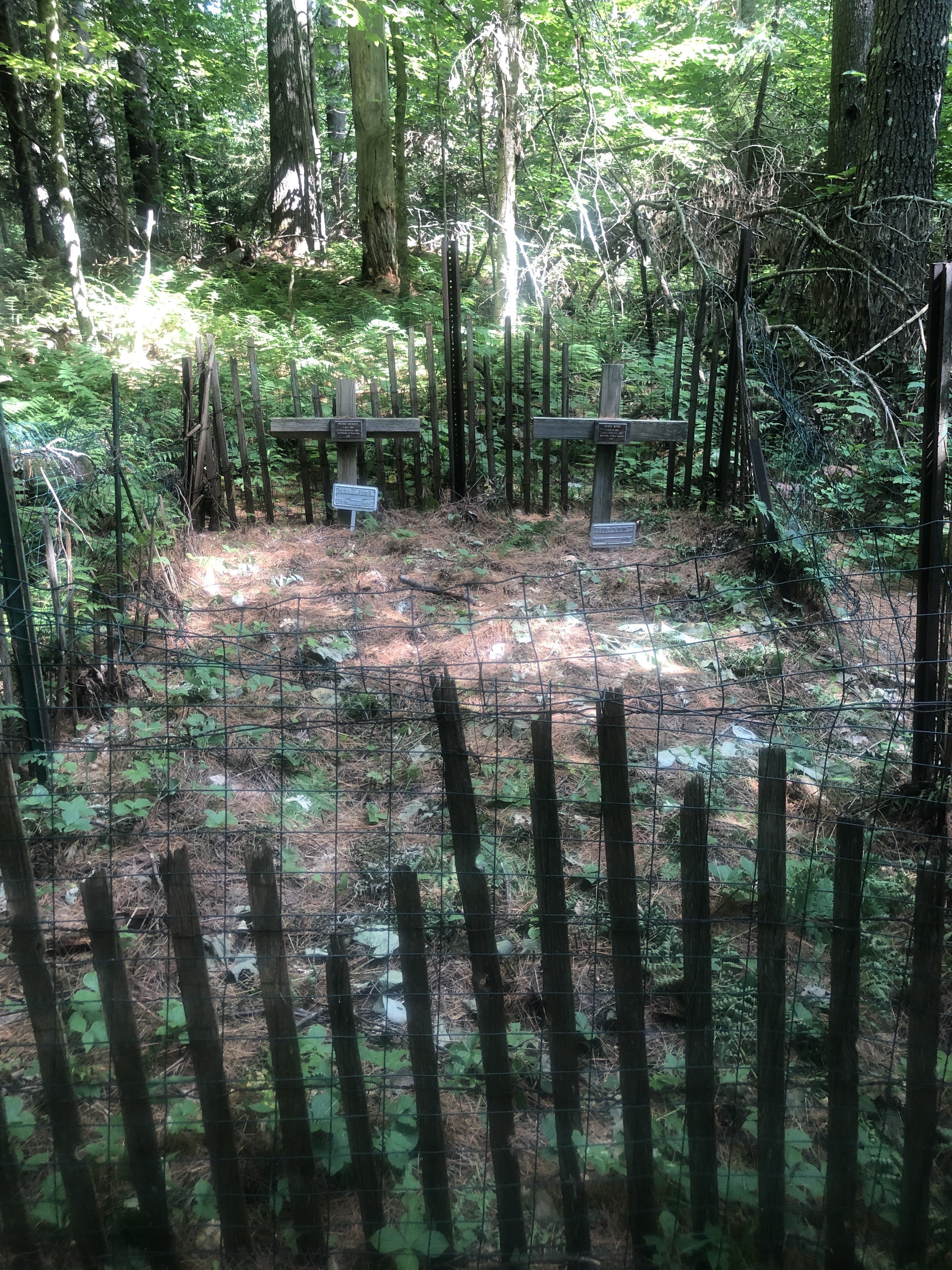
At 1.7 miles, the trail comes to a spur trail on the left leading to the graves of Eliza King and Peter Savarie. A sign on a tree marks the junction. It takes only a minute to walk to the burial site. Surrounded by trees, underbrush and ferns, the graves are marked by simple wooden crosses and protected by a wire fence. The children grew up in a long-vanished logging community known as Little Canada, founded by French Canadians. The little graves prompt reflection on the hardships faced by people whose history is now largely forgotten.
Continuing up the main trail, you soon cross John Pond Brook. A bit farther on, look for a large burl on a red pine on the left side of the trail. A burl is a conspicuous bulge that grows out of the trunk of a tree. Woodcarvers sometimes make bowls out of burls. At almost two miles, you come to a junction. The trail to the right, marked by blue disks, leads to the Puffer Pond Trail. Bear left to stay on the yellow trail. In another 0.25 miles, you come to another junction. The trail on the right leads to Clear Pond. It’s possible to hike about 1.3 miles to Clear Pond and then hike back to the road you started on—a loop of about five miles. To reach John Pond, though, you want to bear left here. Now following red disks, you arrive at the small pond after a few minutes. A well-maintained lean-to sits amid tall red pines and faces the south shore. It’s always fun to leaf through a lean-to journal. Here are a few excerpts that caught my eye: “Beautiful hike with my old Army buddy.” “Still above ground and loving it.” “Absolutely love it here.”
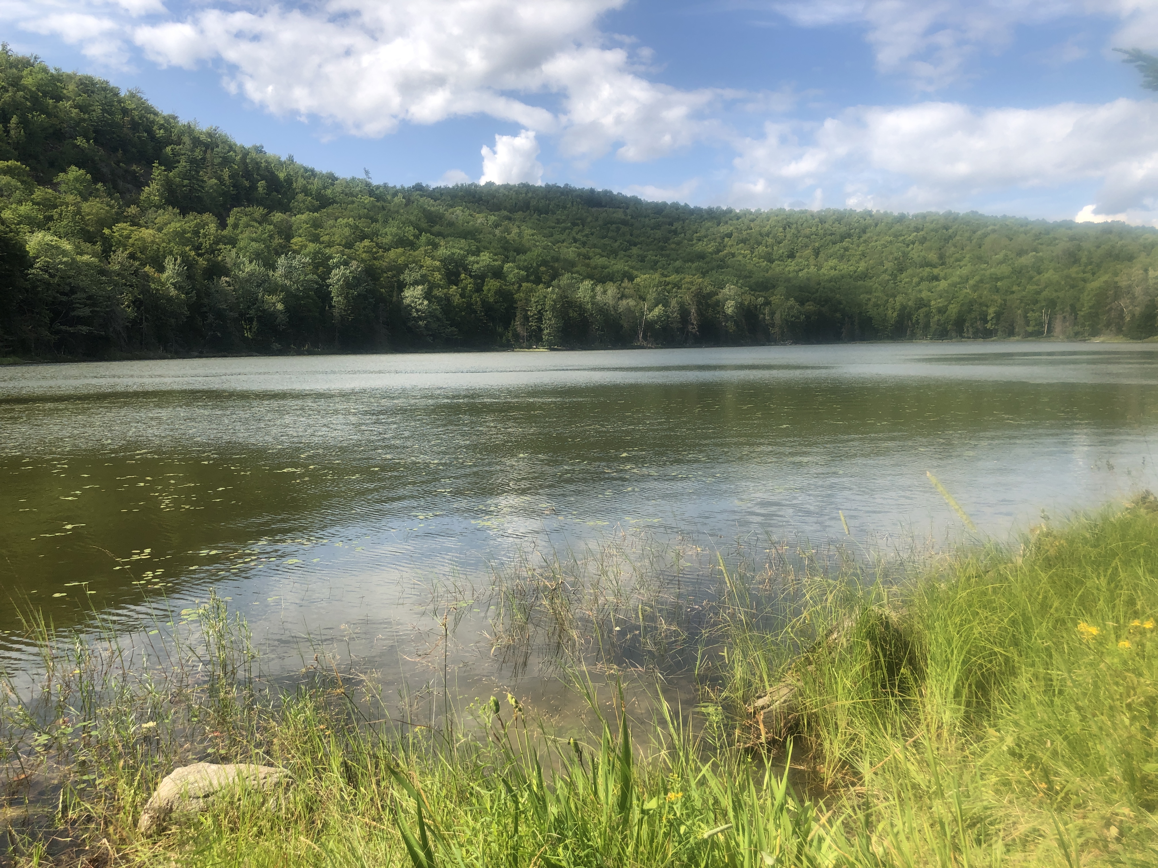
There is a grassy clearing along the water that offers views of the pond and cliffs looming above the west shore. John Pond is a brook-trout pond. To protect this native species, the state Department of Environmental Conservation forbids anglers to use baitfish here.
DIRECTIONS: From the junction of NY 28 and NY 30 in Indian Lake, drive south on NY 30 for 0.6 miles to Big Brook Road on the left. Follow Big Brook Road for 3.3 miles to Starbuck Road. Turn left and go 1.0 mile to a T-intersection with Wilderness Lane. Turn right and go 0.2 miles to the end of the road. Park here or drive up the woods road to the trail register.
This week in ADK news: